Category Archives: Street furniture

Rain/Bridges

I have written two pieces for the Canal & River Trust.

The first is about what it’s like when it rains on a canal boat.Being on the canal when it rained could be a powerful experience, from watching a storm approach you across a basin to the sound of being woken by fat drumbeats of rain on a metal roof at night. I spoke to the writer Melissa Harrison, whose book Rain: Four Walks In The English Weather has just been published in paperback by Faber, and also quote this song by Pulp.

I’ve also written about Eric De Mare, a photographer who explored the dying canal network on a makeshift boat just after the Second World War. His photos, collected in the classic book Canals Of England, were instrumental in reigniting interest in the canal. As an architect, he particularly admired their functional beauty, the simplicity of “architecture without architects”, and the way the bridges, locks and towpaths blended with the natural landscape. He photographed all aspects of the canal, but my favourites are his images of weathered bollards, which he describes as accidental sculptures.

bollard

His bridges are beautiful.

Heywood-Canal-Staffordshire

He would later repeat this sort of work with photographic surveys of the Thames and then the rest of the country’s industrial infrastructure – the breweries, warehouses, docks, factories and, of course, power stations.

eric-de-mare-power-statio-006

The Effra: still flowing under Herne Hill

img_5978

Several of these lovely iron plaques have recently appeared in South London to mark the flow of the River Effra, the lost London river that now lies beneath the streets between Norwood and Vauxhall. It’s a wonderful project and Diamond Geezer has more details. He notes that the first plaques were laid in July and the project appears to be some way from completion, with several plaques yet to be installed. But there is a flurry of them around Herne Hill along Dulwich Road, where they make a nice counterpoint to the Effra’s other principal markers, the stinkpipe.

For those interested in the Effra, a book by Jon Newman has also just been published about the river. I once followed the course of the Effra in the company of a water diviner, who got us all lost in the middle of an estate during a snow storm while taking us on a route that bore very little resemblance to those diligently mapped by Effra experts. Still, it made for an entertaining afternoon.


Great Fire at the Museum of London

I’ve not yet seen the Museum of London’s new Fire! Fire! exhibition, but I did speak to curator Meriel Jeater for a preview in the current issue of World of Interiors.

Jeater told me that a section of the exhibition would look at the conspiracy theories about who started the fire. Some felt that such a devastating conflagration had to have some supernatural origin, so blamed a God angered by London’s heroic capacity for fornication and greed, and its execution of Charles I. Others blamed a more corporeal other in the form of the Catholics, with a Frenchman, the obviously disturbed Robert Hubert, helpfully confessing to arson.

He was hanged and for almost 100 years a plaque (pictured below) was on the wall at Pudding Lane claiming that “here by the permission of heaven, hell broke loose upon this Protestant city from the malicious hearts of barbarous papists”. It was eventually taken down because so many people were stopping to look it traffic could not pass. For years after, people continued to claim responsibility, such as one man who insisted who was inspired by the devil and would do so again, and a boy who said he started the fire with the help of his uncle.

original

The exhibition will feature this plaque, while also looking at the history of fire in London – a resident in 1170 insisted that the “only plagues of London are the immoderate drinking of fools and the frequency of fires” and there were half-a-dozen major fires in the 17th century before 1666. It will then cover how the fire spread and how it was tackled. Numerous artefacts recovered from rubble-filled cellars will go on display, along with contemporary letters by Londoners about the fire. Finally, the exhibition the reconstruction of London, looking at the various plans, the new building regulations and then the reality of how London was finally rebuilt. Illustrating all this will be lots and lots of maps. “It’s hard to get your head round it,” said Jeater. “You look at it and wonder how people coped, how London was put back together again.”

Paul Weller in Uncut

I’ve written the cover story for the latest issue of Uncut about a couple of days I spent in San Francisco with Paul Weller in October.

I enjoyed the incongruous location – Weller was staying in the Japanese district and played a country music festival at Golden Gate Park and a show at hippie landmark Fillmore West – as well as the chance to spend time backstage with Weller and his band unaccompanied by any label management or press officer.

Weller discussed his forthcoming projects, including an avant-garde film soundtrack he’s composed, and also reminisced about early tours of America with The Jam. On one occasion, he said, the band were asked to celebrate their London credentials by posing outside an English pub in Santa Monica with a double decker bus.

The_Jam_bus

I also got the chance to explore San Francisco – where I discovered ghost signs, parrots, a punk-themed restaurant called The Brixton, coyote warnings and a complete absence of cranes, billboards, pneumatic drills and the general intensive building work that blights daily life for so many Londoners.


Getting lost in London: an experiment on Twitter

I recently gave a talk at the Design Museum about walking, and so I  talked about getting lost in London. This is an edited version of my talk.

Five years ago I got my first smartphone and everything changed. I was in Paris on a day trip and I got lost, but instead of doing what I’d always done, which is walk around, try to work out where to go by following my instincts while surreptitiously staring at a map upside down and trying not to look like a tourist, I went straight to my phone, clicked on the map app and immediately located myself – right down to the direction I was facing in. I realised then that I’d never be able to get lost in a city again – or at least until I came up with the idea of an experimental social media walk for the Design Museum, in which I would try to get lost through the misguidance of complete strangers on Twitter.

But let me digress a little.

Getting lost is a valuable experience. Your senses are sharpened, you see more and remember more. I’m sure that getting lost sharpens the imagination – some might say that it’s only by getting lost that we can find ourselves or some such pseudo-psychogeographical bullshit – but my interests are more material. Getting lost is fun. It’s interesting. It’s a great way to explore a city and learn how it is put together.

When I was growing up I was terrified of getting lost in London. When I blogged about my typical Saturday trip as a teenager from the suburbs to London, I was surprised at how repetitive those day trips were, what a narrow furrow I ploughed. My friends and I were only interested in records, clothes and football fanzines, so we’d get the train to Victoria, then the tube to Covent Garden, walk up Neal Street, along Shaftesbury Avenue, up Charing Cross Road, along Oxford Street, down Berwick Street and back along Shaftesbury Avenue to Piccadilly Circus, stopping at various shops along the way. We did this week after week, never straying from these paths.

The other day, I was watching a TV documentary about the sengi, which is a sort of African elephant shrew, and it talked about how these rodents construct runs for themselves in the long grass. These pathways give them a sense of safety, of security, but they can also become a trap: when predators or bush fires arrive, the sengi can’t escape the routes they know so well.

That’s a bit like how I was in London.

That changed when I moved on to a boat in Lisson Grove and began to explore the surrounding streets, getting more familiar with the way London knitted together and using the towpath as a sort of guide rope like a mountain climber. This was partly a matter of circumstances – I had lots of time and little money, so it was cheap to walk and I could afford to take my time getting anywhere, following whatever route seemed most interesting and appropriate. This is what first gave me a sense of the scale of the city, and how endlessly fascinating it can be – the domestic architecture, the quirky shops, the street furniture, the plaques to people you’ve never heard of, the sudden squares – but mostly the curious nature of the topography, which is neither gridlike nor quirkily medieval but something in between, with loads of random curves and bends, making it very hard to navigate.

Later, I conducted more ambitious, planned walks. I walked from St Paul’s to Hampton Court, 26 miles along the river, criss-crossing bridges to stay on the Thames Path. I walked the course of the buried Effra from Gipsy Hill to Vauxhall with a dowser, who used a sort of oversized Allen key to trace the path of this ancient river and in the process got us thoroughly lost in a council estate in Stockwell during a snowstorm. Most memorably, I walked underground from King’s Cross to Blackfriars following the river Fleet with a pair of urban explorers, who spend their spare time breaking into drains.

Spring walks in London: river Effra

In more recent years, opportunities for walks have diminished and I’ve rarely got lost. That’s partly because of the tyranny of the smartphone. With a phone, you always know exactly where you are and the sugary appeal of the web makes it almost impossible to avoid clicking.

So when the Design Museum got in touch, I began to think about walking and technology and wondered whether the power of the smartphone could be harnessed for good: could I use the phone to help myself got lost? I conceived the idea of a walk that would be guided by social media. I’d take a starting pointing – which was obviously the Design Museum – and then ask my followers on Twitter where I should go: left, right or straight ahead. Every now and then I’d take a photograph but otherwise I wouldn’t reveal my location until the end.

The results were mixed. Part of the problem was one of integrity. Should I ask people directions at every single junction, or only ones that looked kind of interesting? I soon realised I couldn’t ask at every single junction, as there were so many of them, and some of them just took me straight back to where I’d come from, or to somewhere I already knew, or on to a long straight road with no end in sight. Conversely, sometimes I’d see a really interesting side street which I couldn’t explore because my followers didn’t send me down it.

Another problem was that my phone is quite old so has a tendency to crash. That meant I stood at a junction on Old Jamaica Road for about ten minutes turning the phone on and off and on and off and on.

The final problem was simply and fairly obviously that staring at a phone while walking, even if this is being done in the service of getting lost, makes it almost impossible to absorb the sights around you and relish the experience it’s all been designed for.

But I did enjoy the interaction with other people – occasionally I’d post a picture and those who recognised it would send me information about the building or street, tell me something interesting about the area, historically or personally. Others talked about doing similar experiments, sometimes in cars, with the passenger telling the driver to turn left or right at random. And while I didn’t get lost, there were definitely several occasions where I didn’t exactly know where I was, until twitter, rather brilliantly steered me back towards the river, which seemed a fitting place to end. The biggest surprise was that I only covered just over a mile in 45 minutes.

walk

There are other ways of getting lost or just exploring London in a more chaotic fashion. The members of the London Psychogeographical Association once explored Globe Town in Mile End using an old US Civil War battlefield map. Somebody once attempted to see how far they could travel from Trafalgar Square without ever crossing a road – he managed to go 17 miles before he began walking in circles somewhere in Hackney. Another acquaintance composed a series of walks that were both complex and rather beautifully simple – he’d walk from the first street beginning with A in the A-Z index to the last beginning with A, then do the same with every other letter in the alphabet.

I also recently discovered a book – Ways To Wander, which has a series of ideas about walking from writers and poets. I liked several especially No 26, which is a version of the twitter walk only using a wooden spoon. You take a spoon, throw it in the air, then walk in the direction it points until you hit a wall, when you do it again. Continue for as long as appropriate.

I quite like the lo-fi nature of that. Perhaps that’s the best way to get lost in London. Leave your phone at home, carry a wooden spoon, and wander.

Ghost street

IMG_3187

I walk past this corner at least twice every day but only recently noticed the ghost sign painted above the newer enamel one. I assume it was previously covered up, otherwise I’m sure I’d have spotted it at some point in the past five years. Perhaps the jutting pipe points to recent usage.

Much as I like a painted street sign, this one is particularly interesting as it dates back to a time when the street – a short stub of road – had a different name entirely. According to Steve Chambers, who knows about such things, this was one of three name changes in the area – including the eradication of the similar Hamilton Terrace on Shakespeare Road – brought about to tidy up postal addresses.

https://twitter.com/respros/status/544505070256418818

https://twitter.com/respros/status/544505963492171778

The ghost sign for the ghost street sits opposite a ghost pub. Hamilton Supermarket occupies the site of the Hamilton Arms, a cosy corner pub opened in 1878 that was captured magnificently in these old photos. It closed in 2004.

hamilton-arms-brixton-6

hamilton supermarket

London: a cycling city

I wrote about the challenges facing cycling in London for The London Magazine

Every time I hear that another cyclist has been killed on one of London’s many lethal junctions, I pray to a god I don’t believe in that it isn’t one of my friends. The idea of cycling in London terrifies me. That’s partly because I haven’t ridden a bike more than twice in 20 years, and partly because I have seen so many incidents, altercations and near fatal collisions involving cyclists during my walks around the city.


I’m aware of the figures – the fact that cycling is overall a pretty safe form of transport, even if it could always be better – but it’s hard to shake off that impression that it’s anything but. I’ve seen cyclists get hit by taxi doors and narrowly avoid getting squashed by buses. I’ve seen them shouting with rage and fear at drivers who’ve turned out of a side street in front of them without looking. I’ve seen them cycle headlong into pedestrians who weren’t looking where they were going (and vice versa). I’ve seen them getting into squabbles with bus drivers about ownership of bus/cycle lines that end with blows being traded. I’ve seen them picking themselves and their bent bikes off the pavement after minor crashes. And I’ve seen the blood getting washed off the road after major ones. It looks anything but fun.

So despite the fact I see people cycling quite easily and happily on London streets every day, I still think it’s one of the last things I’d ever want to put myself or my family through on a daily basis.

That is something that needs to change if London is ever going to be a cycling city, which it desperately needs to if it is to remain in any way a human and pleasant place to live in. People like me need to be persuaded that London cycling is safe and that a trip on the bike to the shops won’t result in a serious injury or a shouting match. As Mike Cavenett of the London Cycling Campaign admitted to me “the striking thing is that Dutch cyclists just look like Dutch people”, by which he means you see the elderly and children, men and women, all cycling in their normal clothes – not like London, where cyclists wear tight, bright clothing and manage to look simultaneously over and under dressed.

When London’s cyclists start to look normal, that’s when we know we are heading the right way. And for that to happen, London needs better infrastructure, streets on which cyclists feel safe and are able to relax, making the whole experience better for everybody. Everybody I spoke to – including Andrew Gilligan, the Mayor’s cycling tsar – seemed united on this and agreed on the direction that London needed to go in. Whether it actually happens, whether there is the political will to spend the cash to keep the promises, remains to be seen. But here’s hoping it starts to happen, because a cycling city would be better London for everybody.

Pathe newsreel: London time machine

These are all taken from the recent cache of thousands of Pathe newsreels loaded on to You Tube.

1. A trip to Swinging London in 67. Is that Yoko reading International Times at Trafalgar Square? Surprisingly sympathetic beneath the patronising tone. I love those Bob Dylan paper dresses. And at 4:50 you get to meet Keith Albarn, father of Damon, as he organises a happening. Also features Mary Quant, the Speakeasy, the Scotch of St James and much more.

2. This Is London, with commentary by Rex Harrison. A tour of the capital for the British Travel Association, starting at the Tower of London, into Fleet Street and Temple then into the West End and Westminster. It’s all very quaint and polite, but great for location spotting. The shots from Chelsea at 10:42 are extraordinary.

3. Platform shoes, 1977. A wide range of Londoners discuss platform shoes – “they’re not natural,” says one cockney. I think this was filmed around the King’s Road.

4. Tracking shots of Soho at night, 1968. No sound or context here, just a series of tracking shots around Soho at night. It’s incredibly atmospheric and full of strange glimpses into past lives, especially the laughing man at 3:22, whose companions have slipped off to an upstairs flat.

5. West End, 1977. Similar to the above, this is a series of disconnected, fairly random shot of London and the West End starting in Chinatown. Silent but fascinating as a sort of moving street photography. Note the number of Scotland fans around Piccadilly Circus, the porn shops, and the huge amount of scaffolding that appears to be everywhere.

7. Making a psychedelic light machine, 1968. A sitar plays while Mike Leonard constructs his machine for a light show. For 60s scene nerds, this is pretty fascinating.

8. White Defence League, 1959. Footage from Notting Hill, featuring an interview outside the HQ of the White Defence League (soundtrack starts around 1.20min). Staggering racism, unapologetically voiced.

Secret London: streets beneath streets of London

Paul, the librarian at Time Out, first told me about the street beneath Charing Cross Road in around 2005. He promised to show it to me, but never did.

Then, last month, I saw it. I was mooching around Cambridge Circus, noting the loss of London’s best-named book shop, Lovejoys, a landmark from the time I used to be a dedicated fanzine-browser across the road at Sportpages, also since departed. I had always assumed Lovejoys was a wittily named Soho porn shop, but it actually stocked cheap classics and DVDs. The shop taking over the site will be a sex shop it seems, albeit of the modern, seedless, air-brushed, air-conditioned variety rather than Soho’s traditional damp basement. With the erasure of any trace of character at the arse-end of Berwick Street, the old Soho sex shop is nearly gone. Indeed, much of this post is about things that have been removed, including Paul the librarian, who left Time Out shortly before I did.

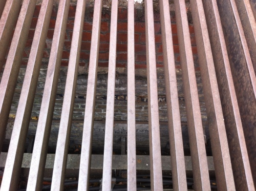
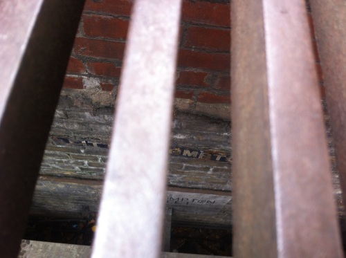
As I crossed Charing Cross Road from Soho and stood on an island in the middle of the road waiting for a No 24 bus to pass, I happened to look into the grille beneath my feet. I have instinctive curiosity when it comes to London holes but this is the first time I’ve really seen anything of interest, as, to my surprise, I could make out what appeared to be a subterranean street sign set into the wall a few feet below the ground.

IMG_1992

I leaned in closer and there they were – not one, but two street signs for Little Compton Street, one blue enamel and the other painted on to brick. Here was London’s buried street.

IMG_1990

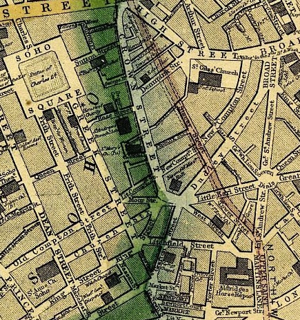
Although Little Compton Street has its own Wikipedia page, it is not entirely clear how the signs got here. The street itself was obliterated by the construction of Charing Cross Road – here you can see Little Compton Street on an old map of 1868, intersecting with Crown Street (which is marked by green as Soho’s border, though surely red would be more appropriate) just before Cambridge Circus. Little Compton Street ceased to exist in around 1896 and is now part of the Cambridge Circus utility tunnels, which some urban explorers write about here. (Apparently, Rimbaud and Verlaine used to drink in a pub on Little Compton Street during their dramatic London stay.)

map1868

Were the underground signs accidentally left behind when Charing Cross Road was run roughshod over the top of Crown Street or was it a careful act of preservation by an unnaturally thoughtful council? Or were they removed from a wall by unknown hand and deliberately placed down here, where Little Compton Street has existed ever since, entombed beneath London feet and offering a tantalising glimpse of those fantasy Londons from countless dreams and dramas. There’s an echo of China Mieville, Neil Gaiman and the Borribles, but also of Malcolm McLaren’s mysterious and misremembered subterranean Victorian road (neatly discussed here) that is said to exist intact beneath Selfridges on Oxford Street.

One wonders whether the brutal Crossrail redevelopment of this bedraggled part of the West End will allow any such traces to remain. I hope so. And I hope they also have this last-gasp, accidental feel, of something that London can’t quite let go, like dying fingernails clawing a wall, leaving behind a ghost, a whisper, of one of London’s many pasts.

For some great old images of Charing Cross Road, browse here with leisure and a little sadness.

London by the bollards

I have a piece in the Autumn 2013 issue of Completely London about London experts, those Londoners who specialise in esoteric subjects like lion statues, ghost signs and stinkpipes. You can read part of it here. My interview with John Kennedy, London’s bollard supremo, didn’t make the cut so I have reproduced it below.

John Kennedy, 47, taxi driver & writer of Bollards Of London
Most people in London get excited about the Tower of London and Buckingham Palace but when you drive a taxi you get bored of the norm and start to look around and notice other things. With me, it’s bollards. It actually began as a bet with ‘Big’ George Webley, a radio presenter. He challenged me to write a blog about something weird and it got picked up by the Guardian. Now I’m really interested in bollards, the way they look, where they are located, what they are used for and how we interact with them.


Bollards have so many uses but most people don’t notice them no matter how colourful, ornate or dandy they are. I really like the Anthony Gormley bollards in Peckham. I love that one of our great contemporary artists is making street furniture. I picked up Charles Saatchi recently and we ended up talking bollards, he found it quite amusing that I had a blog with pictures of 330 bollards. You do get some odd looks when you photograph a bollard – the other day I was spotted taking a picture by somebody. He said, ‘You must be the bollard man.’