Category Archives: Geography

The Effra: still flowing under Herne Hill

img_5978

Several of these lovely iron plaques have recently appeared in South London to mark the flow of the River Effra, the lost London river that now lies beneath the streets between Norwood and Vauxhall. It’s a wonderful project and Diamond Geezer has more details. He notes that the first plaques were laid in July and the project appears to be some way from completion, with several plaques yet to be installed. But there is a flurry of them around Herne Hill along Dulwich Road, where they make a nice counterpoint to the Effra’s other principal markers, the stinkpipe.

For those interested in the Effra, a book by Jon Newman has also just been published about the river. I once followed the course of the Effra in the company of a water diviner, who got us all lost in the middle of an estate during a snow storm while taking us on a route that bore very little resemblance to those diligently mapped by Effra experts. Still, it made for an entertaining afternoon.


On the buses: the first ten routes

Recently, I’ve read a couple of good stories about London bus nuts. There was one on City Metric about the nice German bloke who wants to travel every route and another in Guardian Cities about the guy who wants to ride 200 in 24 hours – though as he only has to ride one stop on each, I’m not all that convinced.

This got me thinking about my own bus travelling endeavours. It began while I was dozing through a meeting on the eighth floor at Time Out, Tottenham Court Road. We were brainstorming ideas for the section I edited, The Big Smoke, and increasingly aware of my own non-contributory silence, I suddenly found myself picking up a thread. Somebody had suggested, I think, doing a piece about the towns at the ends of every tube line, but my brain decided to take this basic concept several steps further, from the realm of the relatively sane into that frightening place where logic, stupidity and over-ambition combine.

“Why don’t I take every bus in London?”

“In numerical order.”

“End to end.”

The fear hit me straightaway. What had I just said? Why had I said it? But Gordon, our voluble editor, was the sort of man who liked to greenlight six impossible ideas before breakfast, and he was enthusiastically in favour. There was no going back on this: On The Buses was born. Every week, armed with a camera, notepad, pen, all-in-one transport map and the desperation of a man with a large hole in his flatplan, I’d leave my colleagues and trot off to some godforsaken corner of London to catch a bus that would take me to some other godforsaken corner of London, where I’d then find the only way to get back to civilisation was via the bus I’d just got off.

In the end, I chose to embrace the reality of my bus-travelling future. There were positives here, I told myself. I could get to see parts of London I’d never usually visit, and as a writer it was an interesting challenge, having to write what was essentially the same column every week while keeping it fresh and amusing. You don’t realise quite how many buses go through Trafalgar Square or Oxford Circus until you decided to write about every single one of them.

I also thought that in difficult times for the print trade this was a handy insurance against the sack: there were several hundred routes in London and surely they couldn’t get rid of me until I’d finished them all?

More fool me. A year or so later, Gordon was replaced by another editor, a man who I’d guess has never ridden a bus in his life and simply didn’t understand why anybody would be interested in such hideous things when you could simply get the BBC to hire you a cab to whisk you from the TV studio to Primrose Hill. We were rarely on the same wavelength, and in one of our first meetings he asked how many bus routes I still had to do. About 650 I told him. ‘I was worried you might say that,’ he replied. Like a man waiting for the No 68 on Herne Hill and spying the X68 coming up the road, I knew precisely what horrors lay ahead.

In a bid to shore up my position  – or possibly I was just being provocative – I then wrote a long feature about other bus enthusiasts. Early in my journeys, I’d received a letter from a woman who was also riding every bus and then during one idle afternoon in the Time Out library, I’d discovered an old bus column written by Alexei Sayle. Clearly there was both a history and a present here; it was living heritage. Exploring the internet further, I discovered there were several of us, including several retirees, plus a lovely bloke called Ben, and an artist, doing a project. Look, I was telling the editor: we are a tribe. We are on trend. People really do like buses.

It made no difference. Within weeks, the column was axed. Within months, I was too. The bus dream was over, and I’d barely made it into the 60s.

For those who care, here are the first ten On The Buses. More available on request.

no1no2no4no3no5

no6no7no8


no9no10


Estuary by Rachel Lichtenstein

I’ve written a review of Rachel Lichtenstein’s very good new book about the Thames Estuary, called Estuary. You can read it here, at Caught By The River.

estuary-jacket

Secret London: South London’s lost canals

I wrote this piece in 2015 for the first issue of Waterfront magazine.

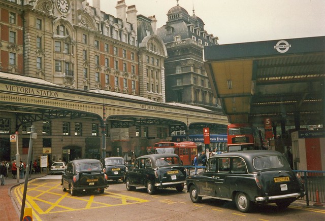
Some of the best secrets are hidden in plain sight. You don’t find them by exploring scruffy back streets and muddy fields, they are standing right in front of you, requiring only a translator to make sense of them. One sits in Burgess Park in Camberwell, ignored by cyclists, dogwalkers and joggers seeking respite from the Walworth Road, one of South London’s busiest byways. It takes the form of a pretty black-and-red iron footbridge with thick brick stanchions and strong stone steps straddling the path. It doesn’t serve any specific function – there’s nothing that needs to be crossed – so is known locally as the “bridge to nowhere”, but this was once a bridge with a purpose. It was built in 1906 to cross the Grand Surrey Canal, one of south-east London’s two lost canals. The park was once a busy industrial basin of wharves and warehouses but over time, the canal was abandoned, closed, filled in and forgotten. Soon, only the bridge remained, a relic or totem of this land’s previous life.

IMG00120-20120814-1050

Like many canals, the Grand Surrey was opened in the brief period between the onset of urban industrialisation and the arrival of railways. It began at Surrey Commercial Dock (now Surrey Quays), a 300-acre system of nine docks two miles east of London Bridge. The original plan was for the Surrey Canal Company to cut a canal from this starting point at Rotherhithe through the south London suburbs. From the main canal, branches would peel off, feeding significant towns on the way south. The object was to create a fast-moving route that could bring produce from Surrey farms into London. An Act was granted in 1801 to build as far as Mitcham, with branches to Deptford, Peckham, Borough and Vauxhall.

At the same time, permission for a second canal was granted. The Croydon Canal was originally going to be its own entity but the Grand Surrey Canal provided a convenient meeting point, and – after some negotiation – the two navigations joined at New Cross. This canal was intended to reach Epsom, but when it opened in 1809 in a ceremony featuring decorated barges, a 21-gun salute and a special song (“Long down its fair stream may the rich vessel glide; and the Croydon Canal be of England the pride”) it stalled at Croydon, having passed through 28 locks from the junction with the Grand Surrey Canal through Honor Oak, Sydenham and Norwood. Nonetheless, it was described by The Times as “one of the highest and best constructed canals in England” and the owners talked about extending it to Portsmouth. Plans for the Grand Surrey also proved over-ambitious, and when it opened in 1807 it went only as far as the Old Kent Road. It reached Camberwell in 1809 and branched off to Peckham in 1826, but got no further.

dooswharf

There are several bucolic illustrations of both canals, presenting them as splendid streams surrounded by countryside. At the opening of the Croydon Canal, a reporter wrote of “finding themselves gliding through the deepest recesses of the forest, where nothing met the eye but the elegant winding of the clear and still canal, and its border adorned by a profusion of trees, of which the beauty was heightened by the tint of autumn.” In 1811, the Grand Surrey Canal was peaceful enough to be used for bathing, causing one Camberwell resident to write a furious letter to The Times objecting to the “indecency” and “extreme offensiveness to females in so public a situation”. Soon after, ‘bank rangers’ – a sort of private police force – were appointed to keep an eye out for lewd or criminal behaviour.

Quickly, though, the landscape changed. Submitted to parliament alongside the proposals for the two canals, was another for the Surrey Iron Railway, which would become the country’s first public railway in 1803, linking Wandsworth to Croydon via Mitcham. Using carriages pulled by horses over iron tracks, the intention was to create an integrated transport network for the expanding suburbs, but ultimately it put the two technologies in direct competition. At first, they cohabited and connected, and the canal even proved superior, but as steam trains arrived, the canals lost any edge. Croydon Canal’s success was further hindered by its expensive, time-consuming locks and the company could tell where things were headed. The canal was dead by 1836, the first in the country to be closed by parliament. The land was purchased by the London And Croydon Railway, who built their line largely alongside the old canal and turned the basin into West Croydon station.

The Grand Surrey Canal was spared such a fate, even if it was to never fulfil the bravura plans made at the outset. Initially the canal was intended to transport numerous goods – the 1801 Act set out rates for freestone, limestone, chalk, bricks, slates, tiles, corn, hay, straw, faggots, dung, manure, stones, clay, cattle, calves, sheep, swine, lime, timber, hemp, tin, bark, iron-stone, pig-iron, pig-lead, coal, charcoal, coke, culm, flour, wheat, barley, oats, beans, peas, malt, potatoes, hops and fruit – but instead of becoming a vibrant link between garden suburbs and London docks, the canal was more like a gigantic wharf, an extension of the Surrey docks lined by warehouses, factories, yards and depots. The canal nonetheless became a useful part of the industrial infrastructure, drawing cargo from all over the world – including a 4ft snake from South America that was fished out the canal at Peckham in 1932 by an angler who at first believed he’d nabbed a particularly fine eel. The industry was largely dirty and unglamorous with numerous timber yards, but there were also R White’s, manufacturers of lemonade, and Edison-Bell, who made 78rpm records and had a recording studio on the premises.

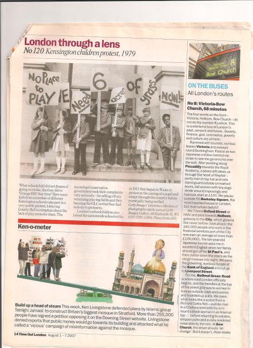
After the Second World War, decline set in. The increase in road traffic offered tougher competition even than rail, while changes in freight transportation threatened the docks themselves. The canal closed in stages from the 1940s. The basin at Camberwell was first to be abandoned, becoming a playground for children, who went fishing for sticklebacks or tore doors off bombed-out houses to sail down the stagnant canal as rafts. Children determined their local sympathies by which side of the bridge they lived.

The bridge was still surrounded by the straggling detritus of light industry, but fears that children would drown – indeed, The Times reported more than a dozen had met this fate since the war, as several had before it – led to the area being cleared in 1974 and replaced by Burgess Park. The canal’s route was turned into a pathway and the bridge retained as a momento. There are further princely bridges on the Peckham arm of the canal, at Willowbrook Road and Commercial Way, while the Peckham basin is now the site of Peckham library. Nearby, a sliver of park connecting Burgess Park to Peckham High Street is known as the Surrey Linear Canal Park, presumably to confuse new arrivals. Elsewhere, there are further pointers: bits of wall, ghosts of towpaths, mooring rings, milestones, and in a park reclaimed from the old Russia Dock in Surrey Quays, a large amount of quayside.

One of the most interesting survivors is a rusting round bollard under a bridge near the junction of the Surrey Canal Road and Mercury Way in New Cross, once the meeting point of the Grand Surrey and Croydon Canals. Embedded in the grassy embankment, it looks as if it has been dropped from the heavens. Little of the Croydon Canal remains, although diligent historians have traced shadows of its passage in the topology of the land between New Cross and Croydon. Some tiny sections are extant in Dacres Wood, a small nature reserve in Forest Hill, and Betts Park in Anerley. The old reservoir in Norwood has been transformed into South Norwood Lake.

There is a strong sense here of what might have been. The Croydon Canal’s life was too brief, and too quickly swallowed by the dramatic forces leading to the rapid urbanisation of south London, to be saved, but the fate of the Great Surrey Canal is not so easily forgivable. Its potential was not unknown. In the 1960s, trip boats from Little Venice would take extended tours across the Thames into the depths of Peckham and Camberwell, and even in the 1970s, some insisted the canal should be saved. One report in 1971 noted the increasingly popularity of the Regent’s Canal and pondered whether similar could yet happen to “the poor, ugly Surrey Canal… [which] had the misfortune to run south of the river.” The author admitted there was an image problem: “Its waters are polluted and filled with rubbish and hunks of wood. Its banks are closed to the public and lined with disused factories and unkempt grass. To many local people it is just three miles of stinking water, which has to be dredged every time a child goes missing.” But should the drastic solution of eradication proposed by Southwark and the Port Of London Authority go unchallenged? “Suggest any redevelopment of Little Venice and fashionable owner-occupiers besiege the local town hall,” he wrote. “Down south of the river, however, they apparently order matters differently. Two public authorities have quietly decided between them to scrub off the map one of South London’s most precious potential assets.” And so disappeared the Grand Surrey Canal, not so much a lost secret as a missed opportunity.

Further reading: http://www.bridgetonowhere.friendsofburgesspark.org.uk/ and http://www.londoncanals.uk/

Beautiful Idiots and Brilliant Lunatics by Rob Baker

For several years, Rob Baker has written one of London’s best blogs, Another Nickel In The Machine, which explores the cultural history of London’s 20th century in a unique way. Rather than focus on, say, a musical genre or a particular locale or an identifiable concept such as celebrities or architecture, Baker simply finds great stories and researches the shit out of them. And now he’s turned it into an excellent book: Beautiful Idiots and Brilliant Lunatics.

As with his blog, Baker doesn’t pretend to find a unifying theme to artificially define the richness of his material, instead relying on his natural instincts to identify a good story and tell it for just the right amount of time. This is crucial. Some of these chapters cover some pretty big subjects – the Krays, Lord Haw-Haw, Christine Keeler, Pop Art – but Baker always manages to find a new angle without going on too long: for instance, his piece on Pop Art concentrates on Pauline Boty and the Anti-Ugly Movement while he looks at Blow-Up through a street in Stockwell that appears in the film. He’s brilliant at detail – clothes, weather, atmosphere, quotes – and tightly wound narrative (the section on the escape of spies Burgess and Maclean could come from a thriller), but he also loves exploring interesting tangents.

But his real skill is contextualising individuals within their era or locality. So his chapter on Benny Hill tells us much about the post-war comedy scene at the Windmill as well as Hill’s own rise and sad decline, the Profumo Scandal chapter is also about Soho and the Flamingo club in the early 1960s while the section of Winifred Atwell takes in Atwell’s strange career as a popular black performer but also the history of Brixton, where she lived.

This is essentially, the book of the blog, with several of the same stories, only expanded with new research. The blog also features great photography, just the right amount of which is reproduced here, including a cracking cover shot from the 100 Club, a venue that increases in importance with each year it avoids closure. Collectively, these photos and historical essays build a picture of London that captures some of the city’s chaotic sensibility far more truthfully than a conventional or even psychogeographical history, which will try and draw dry parallels between then and now, sometimes with lamentable results. Instead, Baker simply tells a story and then leaves you to think about what it means, if anything.

Some of these yarns I knew nothing about, such as the strange days James Earl Ray spent in Earl’s Court after assassinating Martin Luther King, or the spiv murder of Warren Street, or Charlie Chaplin’s wonderful return to Lambeth in 1921. Others I was familiar with, but still learnt more about, such as the plans to redevelop Covent Garden in the 1960s that was stopped by protesters – in the current climate, I wonder, would a similar protest have any success at all?  The net result is like being rattled round the London decades by a raconteur with a time machine, a sort of blue badge Doctor Who, who tells a story with wit and panache before whizzing you off to his next unpredictable destination.

A Saturday in London in the early 1990s

Here are me, Scott and Mike trying to be the Ramones.

Triumvirate

We called ourselves the triumvirate and were inseparable. We were also insufferable poseurs.

Triumvirate2

We spent most Saturdays going up to London. The day usually started here.

Image result for sutton surrey station

The highlight of the train journey came after we passed Clapham Junction and trundled past the hulking mass of Battersea Power Station, which was apparently being turned into a theme park. This classic view of the power station from the railway line is soon to disappear as the building is surrounded by steel and glass boxes for the very rich.

Image result for battersea power station from railway

Crossing the Thames, you could usually make out the floodlights of Craven Cottage and Stamford Bridge if you were quick. There are fewer finer sights in life then the glimpse of far-off floodlight. If all went to plan, we might be getting a closer view before the day was done.

From Victoria, we headed for Covent Garden. Mike was a dresser. He could carry anything off. He still can. Mike had a dapper big brother, Pete, who read The Face and I-D, and so Mike always seemed to know where to go. His keen sense of style didn’t always go down well in the suburbs; when he wore a pair of Adidas shell tops to school, kids in Nike Air and Adidas Torsion laughed at his protestations that he was the trendy one. Still, I was convinced enough to buy a pair of suede Kickers on his say so, and nobody took the piss that much.

We usually went to a few shops on Floral Street and then  Neal Street, maybe first visiting the Covent Garden General Store, which was full of entertaining tat.

We spent much of this part of the day traipsing after Michael into shops where saleswoman would assure him he looked the ‘dog’s bollocks’ as he pulled on another pair of check flares. If I was feeling bold I’d try on something in Red Or Dead or Duffer of St George on D’Arblay Street. On one treasured occasion, Mike’s brother Pete was so impressed by my red Riot + Lagos t-shirt from Duffer that he borrowed it for a party. This was probably the high point of my life as a style icon.

duffer

duffer

After watching Michael try on clothes, we’d go to Neal’s Yard, where we breezed past the weirdos in the skate shop on our way to the basement.

This was the Covent Garden branch of Rough Trade, a pokey den arranged around a metal spiral staircase, with walls covered in graffiti from bands that had played there. We loved it here. Music was one shared passion. Mike had got us into Sonic Youth, Pavement and Teenage Fanclub; Scott’s dad had a great selection of Van Morrison, Leonard Cohen, Jackson Browne and Neil Young. We all read the NME and Melody Maker and Select. This stuff mattered.

After a quick nose, we’d slip on to Shaftesbury Avenue and round to Cambridge Circus. There was a shop south of here on Litchfield Street that sold trendy Brazilian football shirts which we looked at but could never afford. Usually we headed north up Charing Cross Road to Sportspages.

imgresSportspages sold sports books, but we were only interested in the fanzines, which were scattered over the floor in untidy piles. Football was our other passion. I’d try and pick up the hard-to-find Cockney Rebel, a one-man Chelsea fanzine that combined football with an idiosyncratic take on pop and film culture. I went to Sportspages for years but never actually bought a book there.

After that, it was lunchtime.

Image result for bacon double cheeseburger

We lived for bacon double cheeseburgers.

Then we’d head down Hanway Street, past the Blue Posts on the corner, to visit Vinyl Experience, a huge place over a couple of floors which was covered by this fine Beatles mural.

Photo by Ronald Hackston

Photo by Ronald Hackston

At some point earlier, it had this fine sign.

vinylexperience

There were a couple of other record shops here – JBs was a decent one – and we’d often pop into Virgin on Oxford Street to check out the t-shirts.

From there, we strolled down across Oxford Street and cut through Soho down to Berwick Street, where three more record shops awaited – Selectadisc, Sister Ray and Reckless. Selectadisc was my favourite; although the staff were contemptuous, they were marginally friendlier than in Sister Ray and the choice was wider.

Reckless Records Berwick Street

Sometimes we’d see our schoolfriend Martin, who worked the odd Saturday on a fruit and veg stall in Berwick Street market for his uncle. I was always slightly jealous of this; it seemed an impossibly cool, proper London job for suburbanites like us to have.

Football was next. Despite having visited so many shops, we spent more time browsing then buying so rarely had many bags. Most of our serious record shopping was done in Croydon at Beanos.

What game we went to depended on who was playing, how much money we had and whether I could persuade Scott (Wimbledon) and Mike (Celtic) to fork out to watch Chelsea. It usually boiled down to Arsenal in the Clock End, where we could still pay the kids fee, or Chelsea in the Shed. Occasionally we’d duck into the ground at half time, when the exit gates had opened.

If we didn’t fancy Chelsea or Arsenal, or they were away, we’d head over to QPR, Charlton, Millwall and Fulham. Nobody ever sold out.

Chelsea at Arsenal, 1990

Chelsea at Arsenal, 1990

After football, dinner.

dinner

If we had time, we’d pop into the sweet shop in the Trocedero.

And then maybe a gig: at the Marquee or Astoria.

Or more likely home via Victoria, and then out to the Ship or the Firkin in Croydon.

A week or so later, we’d do it all over again.

shed

Many of these places no longer exist, and I’m not even that old. Or at least, I didn’t think I was.

In defence of Midtown

I recently wrote a piece for The London Magazine about Midtown.

Midtown is the bastard offspring name for what people traditionally think of Holborn. For some reason, that really pisses people off. Perhaps it’s the very crassness of the name – Midtown – that deliberate literalness with its clear nod to grid-like American cities where entire areas are known by their compass points. In London, of course, we have nothing like that.

Except the West End.

And the East End.

And the South Bank.

Ah, but they are all different, aren’t they?

It is very easy to get annoyed about Midtown – the idea of it, rather than the place itself, which is pretty inoffensive – but what interested me is why. Why take on the challenge of renaming a traditional part of London? What’s the benefit? How do you summon up the gall? And how do you persuade locals it’s a good idea?

To answer those questions, I spoke to Tass Mavrogordato, Chief Executive of InMidtown, a very nice woman who appears to be permanently on her guard against negative attacks on her Midtown baby. She quickly explained to me that Midtown isn’t another name for Holborn at all. “It’s an umbrella term for the entire area between the West End and the City ,” she says. “We didn’t want to take anything away from the historic areas of St Giles, Bloomsbury or Holborn, and in many ways should help them as it helps to locate them in a wider area. We look at places like the South Bank and can see how these names with a geographical sense have been successful.”

Mavrogordato draws a straight comparison with the West End, an umbrella term that people happily use for a wider area that takes in some of London’s most historic and lovable quarters – Mayfair, Soho, Marylebone – without in any way detracting from them. Nobody has a problem with the West End. Why, she wants to know, can’t Midtown do the same thing, just a bit further east?

It all sounds very logical when she puts it like that, but I doubt people will be convinced.

Part of the problem is one of perception. People don’t like being told what to call places by other people with more money than them. InMidtown is a Business Improvement District and uses aggressive branding to push the concept of Midtown in ways that rubs people up the wrong way – even if the term Midtown predates the BID and has been in use by estate agents since the 1990s.

It’s this noxious aroma of branding that really galls, making Midtown appear distinct from the West End and South Bank, even though these are equally artificial constructions, placing rather spurious boundaries on areas that already had well-defined, historic names. But the latter two appeared more organically, or more to the point they appeared so long ago that nobody actually remembers how they came about, so they are accepted simply because they predate people’s perception of what London is, which was generally formed when they first moved to the city.

London, though, evolves far more quickly than people are comfortable with – and most people don’t actually want London to evolve at all, or at least only in ways that benefits them directly, in the form of better coffee shops or making their flat more valuable, but not so valuable that people a lot richer than them might buy it.

And that gets to the crux of people’s problem with Midtown, it’s change that appears to be directed from above, by outside forces, by money. That’s why people delight in using the ridiculous name Fitzrovia, an inter-war construct for an area that was previously considered to be an extension of Soho, but rejected Noho when that was proposed by developers as it just felt too damned American, too damned money, even if it was, in many ways, more appropriate and certainly no less daft. (Imagine trying to name somewhere Fitzrovia now – you would be laughed out of town, and rightly so.)

There is a consistency here, it’s just a very wobbly one.

And so it goes. Londoners will boast long and loud that London is the greatest city in the world, a barrel of fun for all concerned. Other people will come to London, push the property prices out of orbit and rename the streets so they can get from Lincoln’s Inn Fields to Gower Street without looking at their phone.

And suddenly, it doesn’t seem so much fun.

So in Midtown, poor helpless Midtown, they draw the line.