Category Archives: Maps

Curiocity – the book

Way back in 2011, I wrote this blog post about something I’d been sent in the post. It was called Curiocity and was a tiny fold-up magazine that featured arcane trivia on one side and a weird map on the other. I think I was one of the first – if not the first – to write about the project. The first editions were numbered and then they began to appear in alphabetical order, with each letter indicating the theme, often wilfully obscure and tangential. It was a wizard wheeze, and I even contributed to later editions but Curiocity the magazine only got as far as G, when they stopped. I was miffed, partly because I’d not got round to asking how it should be pronounced – “curio city” or curiosity”?

That’s because the pair behind Curiocity – Henry Eliot and Matt Lloyd-Rose – had been approached to write a book. I remember them announcing this to a bunch of us London nerds in a pub in Farringdon. How, we wondered, was this fascinating map concept going to make it into a book? Well, the answer arrived earlier this year with the publication of Curiocity: In Pursuit of London. If it wasn’t for the publication of Up In Smoke, it would probably be the best London book of the year.

Curiocity side on.JPG

I’m not sure when bookshops started having London sections, but I know that I first became aware of the concept of “London writing” in 1999, when Granta published a marvellous London special. Ackroyd’s biography appeared shortly after and a genre was defined. Since then, the concept has exploded. People have always written books about London, but now it has developed into a mini industry all of its own. My bookshelves groan with London books, many brilliant, others less so. There is, in these London bookshop sections, perhaps an over-reliance on ‘secret/eccentric” London-type books, which all seem to contain pretty much the same information just with slightly different covers. But there are also gazetteers on London place names, London maps, London statues, London rivers, London animals, London graveyards, London pubs, London murders, London folklore… my house is packed with these specialist tomes, the best of which are rich in detail and lovingly compiled.

Even so, I’m tempted to chuck them all out because all this information and more can be found in Curiocity. Ostensibly divided into 26 alphabetic themes, the book basically contains all the London trivia, information and history you’d ever require in one place. The esoteric nature is hard to grasp and harder to describe but for example G is for Grids,  a chapter that takes in everything from bollards to bikes – and the bike page includes entries on velodromes, cyclist cafes, Queen videos, mass transit cycling events, recumbent hire and the serial number of the most ridden Boris bike. It’s a mix of trivia, history and listing information that reminds me of peak-era themed issues of Time Out crossed with The London Encyclopedia and then given the Burroughs cut-up technique. 

What’s particularly edifying is there is no attempt to thin out or dumb down  – it’s a total mind dump, with the editors throwing every possible piece of information they can have at the pages and then worrying how to make them stick later. It’s also beautifully illustrated, with special maps created and conceived for the occasion. And while the gargantuan size takes it a long way from the flimsy fold-up map I first received in 2011, it’s gratifying that the spirit of the project has not only survived but been allowed to expand and prosper to the benefit of anybody fascinated by London books and with space enough on their bookshelves for more.

Curiocity: In Pursuit Of London by Henry Eliot and Matt Lloyd-Rose.


On the buses: the first ten routes

Recently, I’ve read a couple of good stories about London bus nuts. There was one on City Metric about the nice German bloke who wants to travel every route and another in Guardian Cities about the guy who wants to ride 200 in 24 hours – though as he only has to ride one stop on each, I’m not all that convinced.

This got me thinking about my own bus travelling endeavours. It began while I was dozing through a meeting on the eighth floor at Time Out, Tottenham Court Road. We were brainstorming ideas for the section I edited, The Big Smoke, and increasingly aware of my own non-contributory silence, I suddenly found myself picking up a thread. Somebody had suggested, I think, doing a piece about the towns at the ends of every tube line, but my brain decided to take this basic concept several steps further, from the realm of the relatively sane into that frightening place where logic, stupidity and over-ambition combine.

“Why don’t I take every bus in London?”

“In numerical order.”

“End to end.”

The fear hit me straightaway. What had I just said? Why had I said it? But Gordon, our voluble editor, was the sort of man who liked to greenlight six impossible ideas before breakfast, and he was enthusiastically in favour. There was no going back on this: On The Buses was born. Every week, armed with a camera, notepad, pen, all-in-one transport map and the desperation of a man with a large hole in his flatplan, I’d leave my colleagues and trot off to some godforsaken corner of London to catch a bus that would take me to some other godforsaken corner of London, where I’d then find the only way to get back to civilisation was via the bus I’d just got off.

In the end, I chose to embrace the reality of my bus-travelling future. There were positives here, I told myself. I could get to see parts of London I’d never usually visit, and as a writer it was an interesting challenge, having to write what was essentially the same column every week while keeping it fresh and amusing. You don’t realise quite how many buses go through Trafalgar Square or Oxford Circus until you decided to write about every single one of them.

I also thought that in difficult times for the print trade this was a handy insurance against the sack: there were several hundred routes in London and surely they couldn’t get rid of me until I’d finished them all?

More fool me. A year or so later, Gordon was replaced by another editor, a man who I’d guess has never ridden a bus in his life and simply didn’t understand why anybody would be interested in such hideous things when you could simply get the BBC to hire you a cab to whisk you from the TV studio to Primrose Hill. We were rarely on the same wavelength, and in one of our first meetings he asked how many bus routes I still had to do. About 650 I told him. ‘I was worried you might say that,’ he replied. Like a man waiting for the No 68 on Herne Hill and spying the X68 coming up the road, I knew precisely what horrors lay ahead.

In a bid to shore up my position  – or possibly I was just being provocative – I then wrote a long feature about other bus enthusiasts. Early in my journeys, I’d received a letter from a woman who was also riding every bus and then during one idle afternoon in the Time Out library, I’d discovered an old bus column written by Alexei Sayle. Clearly there was both a history and a present here; it was living heritage. Exploring the internet further, I discovered there were several of us, including several retirees, plus a lovely bloke called Ben, and an artist, doing a project. Look, I was telling the editor: we are a tribe. We are on trend. People really do like buses.

It made no difference. Within weeks, the column was axed. Within months, I was too. The bus dream was over, and I’d barely made it into the 60s.

For those who care, here are the first ten On The Buses. More available on request.

no1no2no4no3no5

no6no7no8


no9no10


Great Fire at the Museum of London

I’ve not yet seen the Museum of London’s new Fire! Fire! exhibition, but I did speak to curator Meriel Jeater for a preview in the current issue of World of Interiors.

Jeater told me that a section of the exhibition would look at the conspiracy theories about who started the fire. Some felt that such a devastating conflagration had to have some supernatural origin, so blamed a God angered by London’s heroic capacity for fornication and greed, and its execution of Charles I. Others blamed a more corporeal other in the form of the Catholics, with a Frenchman, the obviously disturbed Robert Hubert, helpfully confessing to arson.

He was hanged and for almost 100 years a plaque (pictured below) was on the wall at Pudding Lane claiming that “here by the permission of heaven, hell broke loose upon this Protestant city from the malicious hearts of barbarous papists”. It was eventually taken down because so many people were stopping to look it traffic could not pass. For years after, people continued to claim responsibility, such as one man who insisted who was inspired by the devil and would do so again, and a boy who said he started the fire with the help of his uncle.

original

The exhibition will feature this plaque, while also looking at the history of fire in London – a resident in 1170 insisted that the “only plagues of London are the immoderate drinking of fools and the frequency of fires” and there were half-a-dozen major fires in the 17th century before 1666. It will then cover how the fire spread and how it was tackled. Numerous artefacts recovered from rubble-filled cellars will go on display, along with contemporary letters by Londoners about the fire. Finally, the exhibition the reconstruction of London, looking at the various plans, the new building regulations and then the reality of how London was finally rebuilt. Illustrating all this will be lots and lots of maps. “It’s hard to get your head round it,” said Jeater. “You look at it and wonder how people coped, how London was put back together again.”

The Blitz: missing buildings and false memories

While researching my recent feature on the Blitz and former bombsites in London, I was keen to find a site that had been destroyed and not yet redeveloped.

There were some tantalising leads.

Peter Larkham, professor of planning at Birmingham School of the Built Environment, provided me with an image he’d discovered years before of a derelict building on Lowndes Street, left fallow in memory of the Blitz.

Lowndes Street

“It was in the chartered surveyor professional magazine,” he explained. “The story was that it was owned by a family, bombed, and they never did anything to it in memory of a son that died in the war. Fifty years later, life had moved on, and the property came up for sale.”

It’s a compelling story but one that was difficult to confirm. The Bomb Damage Maps  showed a couple of strikes on Lowndes Street so I sent an email to Dave Walker, librarian at Kensington and Chelsea and writer of the formidable Library Time Machine blog. Dave put the query across to a colleague at Westminster, as Lowndes Street straddles the boundary between the two councils. Between the two of them, they discovered destroyed buildings at No 30 and Nos 11/12 Lowndes Street but both sites were developed by 1963. It would require further research to get to the bottom of the story as outlined by Professor Larkham and as tantalisingly revealed in the above photograph.

There was similar confusion with regard to another site. This was next to the Hat & Feathers pub on Clerkenwell Road.

Clarkenwell Road

Clarkenwell Road

According to local legend, the site had been demolished by a bomb and used as a car park ever since. For years, you could even see scraps of wallpaper from the destroyed building still attached to the neighbouring wall. The only problem was there was no record of a bomb landing anywhere near this property – itself rather extraordinary given how badly the area had been bombed. It appears that this was a false folk memory, but one that was still being shared today. In the end, I included no empty lots in my piece as I couldn’t find any that comfortably fitted the available facts.

After my piece was published, I was contacted by a photographer, Thom Atkinson. He was about to publish a book called Missing Buildings, looking at precisely this area – the missing spaces between London buildings ostensibly created by bombs. They’d even included an image of the Hat & Feathers site I’d been studying. Like me, Atkinson was intrigued with the way folk memory and evidence didn’t always correspond.

hatfeath

Photograph by Thom Atkinson

Thom said, “We came across the same sort of folklore thing a couple of times, and in a way that’s what the book is about. There’s a picture we made on Sclater Street, near Shoreditch Station, and the market traders there were talking about it being a bombsite when they were kids. When we looked at the map it didn’t quite fit their story – but they remembered it so clearly.”

There were several explanations for this, false memory being only one of them. As Thom explained, “Sometimes bombs are recorded and the site itself displays all the signs, but no building damage is shown on the LCC map. And of course the whole thing is complicated because the LCC maps only show damage during wartime – we’ve heard stories of buildings falling down or being demolished later on, because of underlying structural damage caused by the bombing – one of the guys who works in the processing lab (also a bombsite by the way!) has a house in East London with cracked foundations; the surveyor thinks they were caused by a bomb landing at the other end of the street.”

Missing Buildings is a wonderful book, showing the ghosts of London homes, many of which have long disappeared but still leave an imprint on neighbouring buildings in the form of shadows, new brickwork, girders and the spectres of chimney breasts. Others have been filled in with new buildings that stand out ridiculously against their neighbours, awkward and ugly, eternally temporary.

There are more of these spaces than you might imagine in London, but they are vanishing fast and this book is an exquisite record of the spaces that get left behind, often more by accident then design. You can buy it here.


Getting lost in London: an experiment on Twitter

I recently gave a talk at the Design Museum about walking, and so I  talked about getting lost in London. This is an edited version of my talk.

Five years ago I got my first smartphone and everything changed. I was in Paris on a day trip and I got lost, but instead of doing what I’d always done, which is walk around, try to work out where to go by following my instincts while surreptitiously staring at a map upside down and trying not to look like a tourist, I went straight to my phone, clicked on the map app and immediately located myself – right down to the direction I was facing in. I realised then that I’d never be able to get lost in a city again – or at least until I came up with the idea of an experimental social media walk for the Design Museum, in which I would try to get lost through the misguidance of complete strangers on Twitter.

But let me digress a little.

Getting lost is a valuable experience. Your senses are sharpened, you see more and remember more. I’m sure that getting lost sharpens the imagination – some might say that it’s only by getting lost that we can find ourselves or some such pseudo-psychogeographical bullshit – but my interests are more material. Getting lost is fun. It’s interesting. It’s a great way to explore a city and learn how it is put together.

When I was growing up I was terrified of getting lost in London. When I blogged about my typical Saturday trip as a teenager from the suburbs to London, I was surprised at how repetitive those day trips were, what a narrow furrow I ploughed. My friends and I were only interested in records, clothes and football fanzines, so we’d get the train to Victoria, then the tube to Covent Garden, walk up Neal Street, along Shaftesbury Avenue, up Charing Cross Road, along Oxford Street, down Berwick Street and back along Shaftesbury Avenue to Piccadilly Circus, stopping at various shops along the way. We did this week after week, never straying from these paths.

The other day, I was watching a TV documentary about the sengi, which is a sort of African elephant shrew, and it talked about how these rodents construct runs for themselves in the long grass. These pathways give them a sense of safety, of security, but they can also become a trap: when predators or bush fires arrive, the sengi can’t escape the routes they know so well.

That’s a bit like how I was in London.

That changed when I moved on to a boat in Lisson Grove and began to explore the surrounding streets, getting more familiar with the way London knitted together and using the towpath as a sort of guide rope like a mountain climber. This was partly a matter of circumstances – I had lots of time and little money, so it was cheap to walk and I could afford to take my time getting anywhere, following whatever route seemed most interesting and appropriate. This is what first gave me a sense of the scale of the city, and how endlessly fascinating it can be – the domestic architecture, the quirky shops, the street furniture, the plaques to people you’ve never heard of, the sudden squares – but mostly the curious nature of the topography, which is neither gridlike nor quirkily medieval but something in between, with loads of random curves and bends, making it very hard to navigate.

Later, I conducted more ambitious, planned walks. I walked from St Paul’s to Hampton Court, 26 miles along the river, criss-crossing bridges to stay on the Thames Path. I walked the course of the buried Effra from Gipsy Hill to Vauxhall with a dowser, who used a sort of oversized Allen key to trace the path of this ancient river and in the process got us thoroughly lost in a council estate in Stockwell during a snowstorm. Most memorably, I walked underground from King’s Cross to Blackfriars following the river Fleet with a pair of urban explorers, who spend their spare time breaking into drains.

Spring walks in London: river Effra

In more recent years, opportunities for walks have diminished and I’ve rarely got lost. That’s partly because of the tyranny of the smartphone. With a phone, you always know exactly where you are and the sugary appeal of the web makes it almost impossible to avoid clicking.

So when the Design Museum got in touch, I began to think about walking and technology and wondered whether the power of the smartphone could be harnessed for good: could I use the phone to help myself got lost? I conceived the idea of a walk that would be guided by social media. I’d take a starting pointing – which was obviously the Design Museum – and then ask my followers on Twitter where I should go: left, right or straight ahead. Every now and then I’d take a photograph but otherwise I wouldn’t reveal my location until the end.

The results were mixed. Part of the problem was one of integrity. Should I ask people directions at every single junction, or only ones that looked kind of interesting? I soon realised I couldn’t ask at every single junction, as there were so many of them, and some of them just took me straight back to where I’d come from, or to somewhere I already knew, or on to a long straight road with no end in sight. Conversely, sometimes I’d see a really interesting side street which I couldn’t explore because my followers didn’t send me down it.

Another problem was that my phone is quite old so has a tendency to crash. That meant I stood at a junction on Old Jamaica Road for about ten minutes turning the phone on and off and on and off and on.

The final problem was simply and fairly obviously that staring at a phone while walking, even if this is being done in the service of getting lost, makes it almost impossible to absorb the sights around you and relish the experience it’s all been designed for.

But I did enjoy the interaction with other people – occasionally I’d post a picture and those who recognised it would send me information about the building or street, tell me something interesting about the area, historically or personally. Others talked about doing similar experiments, sometimes in cars, with the passenger telling the driver to turn left or right at random. And while I didn’t get lost, there were definitely several occasions where I didn’t exactly know where I was, until twitter, rather brilliantly steered me back towards the river, which seemed a fitting place to end. The biggest surprise was that I only covered just over a mile in 45 minutes.

walk

There are other ways of getting lost or just exploring London in a more chaotic fashion. The members of the London Psychogeographical Association once explored Globe Town in Mile End using an old US Civil War battlefield map. Somebody once attempted to see how far they could travel from Trafalgar Square without ever crossing a road – he managed to go 17 miles before he began walking in circles somewhere in Hackney. Another acquaintance composed a series of walks that were both complex and rather beautifully simple – he’d walk from the first street beginning with A in the A-Z index to the last beginning with A, then do the same with every other letter in the alphabet.

I also recently discovered a book – Ways To Wander, which has a series of ideas about walking from writers and poets. I liked several especially No 26, which is a version of the twitter walk only using a wooden spoon. You take a spoon, throw it in the air, then walk in the direction it points until you hit a wall, when you do it again. Continue for as long as appropriate.

I quite like the lo-fi nature of that. Perhaps that’s the best way to get lost in London. Leave your phone at home, carry a wooden spoon, and wander.

The legacy of the Blitz

I wrote a piece for the Guardian about the way modern London is still shaped by the bomb damage of the Blitz. This was a subject I immersed myself for several weeks and the first draft of my article is very different to the version that was published. I thought it might be interesting to reproduce the original article on The Great Wen. 

————————–

When travel writer HV Morton surveyed London in 1951’s In Search of London, it was still scarred by war. The Blitz had started on 7 September 1940 and more than a decade later, London was a “city of jagged ruins, of hob grates perched in the sunlight in shattered walls, of cellars draped with willow-herb and Canadian fleabane.” As Morton wandered sadly round Cripplegate – an area now covered by the Barbican – he looked “across an area of devastation so final and complete that the memory of it will always rise in my mind whenever I hear the word Blitz. Thousands of buildings have been burnt and blasted to the cellars. Here and there the side of a building rises gauntly from the rubble, a detached gateway stands by itself in the undergrowth, the towers of a few churches, or a spire, lift themselves mournfully, like tombstones in a forgotten cemetery…. How can anyone reconstruct a town from its cellars?”

The scale of this destruction can be gleaned from the bombsight.org website, which uses information from the National Archives to pinpoint every individual bomb strike, and The Bomb Damage Maps 1939-1945, created by the London County Council and now published as a book, which show colour-coded bomb damage on a building-by-building basis. The maps were originally created for financial reasons, but post-war planning was always an issue. “The heart of it was insurance and compensation,” says Laurence Ward, the book’s editor and senior archivist at the London Metropolitan Archive. “But they had one eye on post-war reconstruction and the maps were essential tools for rebuilding London. They give a bird’s eye view of the damage and use a colour scheme that makes it easy to see areas that needed to be cleared.”

By cross-referencing Bomb Damage Maps with the A-Z and www.bombsight.org, London’s post-war evolution can be explored, with modern parks, offices and housing estates replacing black blocks of destruction. As Ward explains, “The maps help areas make sense, they show why the streets look like they do.” We look at six examples that show some of the ways the Blitz shaped contemporary London, and how that process is still continuing today.

Mayday Gardens, SE3

Alan Lee Williams was 10 when his home in Mayday Gardens, near Blackheath, was hit by a parachute mine. “It was meant for the Thames, but damaged 27 houses and took our roof off,” he recalls, now 84 and reflecting on a life that included a period as Labour MP for Hornchurch. Williams’ house was repaired but several houses – marked black for “total destruction” on the bomb maps – remained derelict throughout the war. “They became places for children to play,” says Williams. “They built a big water tank on them for the fire engines, and sometimes we’d swim in it.”

Visit Mayday Gardens now and you’d have no idea anything had happened here. Unlike other streets, where former bomb sites can be identified by the post-war housing blocks that interrupt Victorian terraces, the destroyed houses in Mayday Gardens were rebuilt exactly as before. “They look as if they have been there all the time and I’m sure most people living there have no idea what happened,” says Williams. Indeed, when a local resident – who declined to be named – was asked if they knew of the street’s history, they admitted it came as news to them. “There was no consistency with the reconstruction,” says Ward. “These have pretty good plots and they probably decided it would be easier to rebuild a couple of houses then build a low-rise block.” One issue would have been the material available, with bricks remaining in short supply until the 1950s despite the LCC’s ability to salvage 140 million from damaged houses. The reconstruction of these middle-class homes, though, comes as stark contrast to the way many working-class districts were treated.

IMG_1342

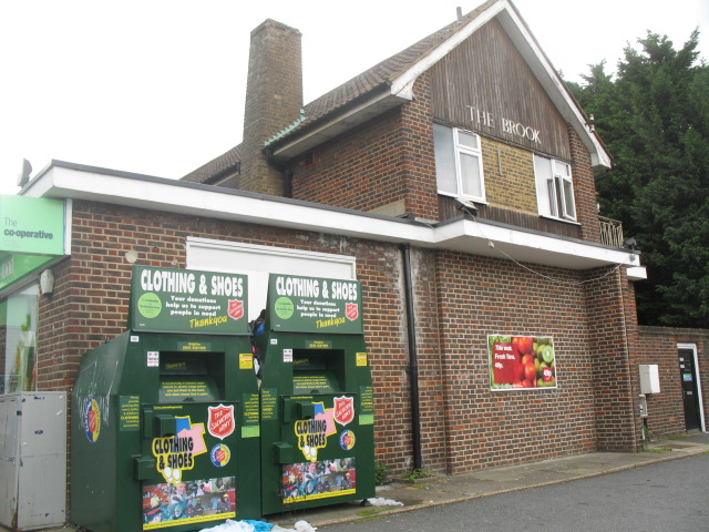
Co-Op, Brook House, Shooters Hill, SE18

A short walk from Mayday Gardens on the corner of Shooters Hill and Corelli Road is an ugly squat building housing a supermarket. This was the site of the Brook Hotel pub, which was hit by a V2 rocket in November 1944.

Alan Williams, then 14, was one of the first on the scene. “I was on a tram on Shooters Hill, when I heard an explosion and ran down the road just in time to see a No 89 bus explode,” he says. “The pub had been hit by the missile and the bus was passing and caught fire.”

Williams was pressed into service. “The fire officer called for silence so we could listen for people calling for help and we heard somebody,” he says. “The firemen were too big to go down, so they lowered me. I found a body still breathing and helped them pull it back up. We got to the top and the gas blew up beneath us – I never got out of a bombsite so quickly.”

He’d rescued a girl who had been playing with the publican’s daughter. “She lived in the same road as me, and her father was a high-ranking policeman,” says Williams. “He came to see us – my mother thought I’d been in trouble again!” In the carnage, 29 died but the pub was rebuilt immediately. “The pub was a lovely old building,” says Williams. “It was close to where soldiers were billeted so they rebuilt it before the end of the war.” Williams passes such bombsites frequently. “I still live in the area and I bow my head as I go past,” he says. “I can still see that 89 bus exploding. I always thought it was strange that there was never an explanation of what happened to these places. I thought they should have put up plaques. It’s always a puzzle why it didn’t happen, maybe they just wanted to forget.”

IMG_1340

Christ Church, Newgate

There are some memorials, if you know what to look for. Churches played an important role before and after the Blitz. Bombed churches were used as propaganda – a famous wartime photograph shows St Paul’s sheathed in smoke – and London’s churches took a pounding: 624 of 701 churches were damaged, of which 91 were destroyed. Many City churches were damaged by the fire bombs of 29 December 1940, which levelled entire streets.

Almost immediately, a debate began about what to be done with the most badly damaged churches. Architect Sir Edwin Lutyen argued in 1941 that “where there is no congregation I would leave the spaces occupied by destroyed churches as open”, partly as a memorial. In 1944, a letter in The Times presciently articulated this principle: “The time will come – much sooner than most of us to-day can visualize – when no trace of death from the air will be left in the streets of rebuilt London. At such a time the story of the Blitz may begin to seem unreal not only to visiting tourists but to a new generation of Londoners. It is the purpose of war memorials to remind posterity of the reality of the sacrifices upon which its apparent security has been built. These church ruins, we suggest, would do this with realism and gravity”.

The creation of these memorial-ruins was rooted in realism – with attendances in decline, churches simply weren’t always needed. The medieval church of Christ Church, Newgate had been rebuilt by Sir Christopher Wren in 1687 after the Great Fire and then razed again in the inferno of December 1940. It has been left in its ruined state in memory of the Blitz, but in bastardised form.

In 1981, neo-Georgian offices were added in imitation of the 1760 vestry – these currently house a dentist. Two walls to the east were removed in 1974 in a road-widening scheme, while the tower – with a steeple that Ian Nairn considered one of Wren’s finest – was transformed into a 12-storey private home in 2006. Merrill Lynch’s office squeezes against the wall of the church and the fact these gardens act as a memorial to the Blitz probably goes unnoticed by local workers – it’s all far too tidy for one thing. A short-lived campaign was launched in 2013 to turn this into a more thoughtful memorial to the sacrifice of Londoners, of which there are few. Christ Church at least fared better than another memorial-ruin: St Mary Aldermanbury was sold to Westminster College in Fulton, Missouri to act as a memorial to Winston Churchill. London still awaits a fitting tribute.

Old Market Square, Columbia Road, E2

A complex network of priorities faced London’s post-war rebuilders, many of whom had been agitating to reconstruct London since before the war. This bore curious fruit in Columbia Road in Bethnal Green, now the location of a flower market and genteel Victorian terraces but then considered a slum. On the first day of the Blitz, a bomb hit a shelter beneath Columbia Market, killing 38. “Columbia Market was a 19th century development founded by Angela Burdett-Coutts to regenerate the area and improve quality of life,” explains Ward.” The buildings were damaged during the war and subsequently demolished – but, it seems, they could have been repaired – the map notes that the main blocks suffered only general blast damage.”

Burdett-Coutts was a philanthropist and friend of Charles Dickens, and Columbia Market was a combination of market and social housing constructed in a dramatic neo-Gothic style that marked one of the first flowerings of Victorian social housing. The ambitious scheme was deemed a “splendid failure” by The Times in 1936 and after the war was being used for storage. Although salvageable and unquestionably important, it was demolished in 1960 and replaced by Ravenscourt Park and a modern tower block, named Old Market Square in a half-hearted nod to what was lost. This new estate is typical of the buildings that were thrown up after the war to solve the problem of slum housing. A campaign is ongoing to get a plaque erected in memory of those that died.

IMG_1352

In the haste to rebuild London, many important buildings were demolished, inadvertently spawning the modern heritage industry. “The idea of heritage and listing buildings only really started after the war, when things were demolished so rapidly we don’t know exactly what was demolished and what was valuable,” says Peter Larkham, professor of planning at Birmingham School of the Built Environment, who has written on post-war reconstruction. “It was launched as a problematic and ad hoc system that allowed councils to designate conservation areas. After development stopped with the 1970s oil crisis, conservation almost took over and we now have 10,000 conservation areas and half a million listed buildings. Some think we conserve too much.” The only remaining trace of Columbia Market is a section of railing outside a nursery. “It’s a fascinating building that most have cost a fortune and completely dominated the road,” says Ward. “Now you’d never know it existed.”

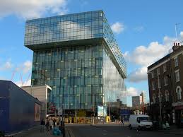
Palestra, Blackfriars Bridge Road, SE1

This 1990s office block sits atop a site with a fascinating jumbled history. In 1783, the Surrey Chapel was built amid fields by Georgian preacher Rowland Hill, who chose a circular – or octagonal – form as this meant there were no corners where the devil could hide. By 1910, it was being used as a warehouse when boxer Dick Burge decided to turn it into a boxing venue. The Ring was a success but was hit by a bomb on 25th October 1940 and then again in March 1941. According to the Bomb Damage Maps the spot was also later hit by a V1 flying bomb. Damage from one of these strikes can still be seen a few yards away under a railway bridge.

Like many bombsites, The Ring wasn’t replaced until the 1960s. “Some materials required for building were rationed until 1954,” says Larkham. “Every bomb-damaged city was arguing with the government for their allocation of steel and you might have a site and a plan but you might not be able to do anything with it. Britain was selling steel to Australia because the economy was more important than rebuilding.” Eventually Richard Seifert’s gaunt Orbit House was raised on the site. Seifert, one of the UK’s most prolific post-war architects, loved to give his buildings space-age names, and this one also had a circular nod to The Ring. It housed records for the India Office.

But Orbit House’s time was fleeting. In the 1990s it was replaced by Will Alsop’s gargantuan glass Palestra, which is used by TfL. Peter Rees, the City’s former head of planning, once told me that modern office buildings have a life of around 30 years – something that has more to do with the changing requirements of office life than architectural trends – and that’s how long Orbit House lasted. But with his new building, Alsop paid reference to both of Palestra’s forefathers: like Orbit House, it is raised above the road on a pedestal, while its name comes from the Greek word for a wrestling ring. What’s interesting, though, is that as with much of London’s post-war offices – include huge swathes of the City – this site is already on its second generation of development. Larkham questions if that is sustainable. “One of the worst products in terms of sustainability is concrete,” he says. “The fact we can put these building up and then pull them back – is that really the best solution? We need to design for more flexible longer-term planning.”

Elephant Park, SE17

You won’t find Sayer Street on a map but you can hunt it down in photographs. One on the IWM website shows a family sitting at a dinner table outside the Blitzed shell of Sayer Street School eating egg and bacon supplied by American aid.

Another shows Sayer Street before the Blitz, when it consisted of five-storey tenements in one of London’s poorest areas around Elephant & Castle. Elephant was badly hit by bombs, and Sayer Street is riddled with damage on the Bomb Damage Maps. Before the war, the street contained a fishmongers, cat meat dealer, grocer, saddler, bookbinder; after the war, it was the location of a car park, one of the most popular post-war uses for bombsites. The NPC car park empire began with the purchase of a £200 bomb site on Red Lion Square.

In his memoir The Likes Of Us, Michael Collins writes how in the 1960s he explored Elephant’s remaining bombsites, “on which relics of former homes hovered, exposed broken fireplaces and floral or barley corn wallpaper that had witness births, deaths, Christmases, parties, tears, arguments, laughter and sex.” Sayer Street survived this half-life into the 1960s, when it was chewed up by the Heygate Estate. The Heygate was originally conceived as one of three gigantic housing estates that would stretch from Elephant to Peckham, linked by walkways and ramps for two miles. “It was said the planners decided which streets would be erased in the back of a taxi as they were driven around the neighbourhood,” writes Collins, who was forced from his childhood home. One of those to disappear was Sayer Street.

As Larkham explains, “some of the plans were incredibly radical, sweeping away neighbourhoods irrespective of damage and replacing them with high-rise towers nobody wanted to live in.” These were fuelled by idealism, but as early as 1945, the planner CB Purdom had warned of the dangers in How Shall We Rebuild London?, explicitly rejecting Le Corbusier and “the megalomaniac proposals of those who regard the metropolis as a hive of near termites speeding their existence upon escalators or in tubes.” Such pleas were ignored and towers went up on bomb sites all over London. Some were successful like the Barbican, but most were bleak, poorly built and badly maintained.

The Heygate was rarely popular but it housed many of London’s poorest and now it too is gone, having lasted 37 meagre years. Southwark sold it to Land Lease, a private developer and demolition began in 2011. Former residents have been shipped miles from London, displaced even more brutally than those who once lived on Sayer Street. In its place will come Elephant Park, a residential village of towers and plazas, where a three-bed apartment costs £2.5m. “It says a lot about where London is heading, how it is become more like Paris with those areas of social housing being pushed further out,” says Ward. The ripples from London’s post-war redevelopment continue to be felt, and from Blitzed streets and lost bombsites, another London arises. How long will this one last?

Secret London: deliberate mistakes in the A-Z

IMG_20141107_114231

You can’t trust a map. Not even the A-Z.

A BBC TV programme several years ago first revealed to many people the news that the A-Z contains deliberate mistakes. These ‘trap streets‘ are inserted as a way to protect copyright – if the map is reproduced or copied without permission, the map manufacturers will immediately be able to spot them (see more here).

(A comment at Reddit clarifies this: the map itself cannot have a copyright as it is a “representation of fact… The trap streets and deliberate mistakes change the work from being purely factual into a creative expression and thus able to be protected by copyright.”)

Nobody is quite sure exactly how many mistakes each A-Z contains or where or how long they last for, but the BBC said there were about 100 and named one, Bartlett Place, a real street which was actually called Broadway Walk and renamed thus in future maps.

Another deliberate mistake can be seen on the photo at the top of this page. Can you spot what it is?

See the ‘ski slope’ in the park just next to the city farm? That’s one of the A-Z’s little phantoms. It comes from an old copy of the A-Z (and many thanks to reader Andrew Lyn) for sending the photograph, as the ‘ski slope’  hasn’t been used for about a decade.

If anybody is aware of any other other deliberate mistakes in recent A-Zs, please let us all know.

Phyllis Pearsall and searching for truth in the A-Z

I’ve written before about the urban legend surrounding Phyllis Pearsall, and her oft-repeated claims that she created the A-Z by walking every inch of London streets even though she could have just picked up the London street atlas created by her father, Alexander Gross, a few years before.

Pearsall related how she single-handedly created the A-Z in a pair of self-published unreliable memoirs and this became the definitive account after the publication of this biography. The story of Pearsall’s life has now been made into a musical, The A-Z Of Mrs P, at Southwark Playhouse.

The veracity of Pearsall’s claims is robustly challenged by her half-brother, Alex Gross, who has created a website dedicated to establishing the truth behind the creation of the A-Z and the key role played in it by his and Pearsall’s father, Alexander Gross. The image below comes from Gross’s map and show how much it looks like the A-Z. An excellent comparison of the two maps can be found in Peter Barber’s London: A History In Maps.

IMG_2230[1]

A summary of Gross’s argument can be found here. Gross is hugely critical of the story Pearsall created. He is adamant that Pearsall was operating at the direction of her father to update his already existing London street atlas and is dismissive of her claims that she walked the streets for 18 hours herself, or delivered early copies of the A-Z herself by wheelbarrow. I have no way of telling whether Gross is accurate in his own recollections, but I know that his skepticism towards Pearsall’s claims are shared by Peter Barber, who is head of the map collection at the British Library.

Gross is scathing about Sarah Hartley’s book on Pearsall, Mrs P’s Journey, claiming it has more in common with ‘chick lit’ than it does biography (never having read either ‘chick lit’ or Hartley’s book, I cannot pass opinion on this). Gross also casts a withering eye over Pearsall’s own books about her life in great detail. There is also considerable biographical material on Gross’s relationship with both his father and half-sister, later describing her as ‘urbane, witty, and utterly personifying the spirit of the English eccentric’, something that goes a long way towards explaining why her version of history has been so widely embraced by the British public.

Secret London: streets beneath streets of London

Paul, the librarian at Time Out, first told me about the street beneath Charing Cross Road in around 2005. He promised to show it to me, but never did.

Then, last month, I saw it. I was mooching around Cambridge Circus, noting the loss of London’s best-named book shop, Lovejoys, a landmark from the time I used to be a dedicated fanzine-browser across the road at Sportpages, also since departed. I had always assumed Lovejoys was a wittily named Soho porn shop, but it actually stocked cheap classics and DVDs. The shop taking over the site will be a sex shop it seems, albeit of the modern, seedless, air-brushed, air-conditioned variety rather than Soho’s traditional damp basement. With the erasure of any trace of character at the arse-end of Berwick Street, the old Soho sex shop is nearly gone. Indeed, much of this post is about things that have been removed, including Paul the librarian, who left Time Out shortly before I did.

As I crossed Charing Cross Road from Soho and stood on an island in the middle of the road waiting for a No 24 bus to pass, I happened to look into the grille beneath my feet. I have instinctive curiosity when it comes to London holes but this is the first time I’ve really seen anything of interest, as, to my surprise, I could make out what appeared to be a subterranean street sign set into the wall a few feet below the ground.

IMG_1992

I leaned in closer and there they were – not one, but two street signs for Little Compton Street, one blue enamel and the other painted on to brick. Here was London’s buried street.

IMG_1990

Although Little Compton Street has its own Wikipedia page, it is not entirely clear how the signs got here. The street itself was obliterated by the construction of Charing Cross Road – here you can see Little Compton Street on an old map of 1868, intersecting with Crown Street (which is marked by green as Soho’s border, though surely red would be more appropriate) just before Cambridge Circus. Little Compton Street ceased to exist in around 1896 and is now part of the Cambridge Circus utility tunnels, which some urban explorers write about here. (Apparently, Rimbaud and Verlaine used to drink in a pub on Little Compton Street during their dramatic London stay.)

map1868

Were the underground signs accidentally left behind when Charing Cross Road was run roughshod over the top of Crown Street or was it a careful act of preservation by an unnaturally thoughtful council? Or were they removed from a wall by unknown hand and deliberately placed down here, where Little Compton Street has existed ever since, entombed beneath London feet and offering a tantalising glimpse of those fantasy Londons from countless dreams and dramas. There’s an echo of China Mieville, Neil Gaiman and the Borribles, but also of Malcolm McLaren’s mysterious and misremembered subterranean Victorian road (neatly discussed here) that is said to exist intact beneath Selfridges on Oxford Street.

One wonders whether the brutal Crossrail redevelopment of this bedraggled part of the West End will allow any such traces to remain. I hope so. And I hope they also have this last-gasp, accidental feel, of something that London can’t quite let go, like dying fingernails clawing a wall, leaving behind a ghost, a whisper, of one of London’s many pasts.

For some great old images of Charing Cross Road, browse here with leisure and a little sadness.

Know London

City-lit London

This is an edited extract of an introduction I wrote for City-Lit London, a superb anthology of London writing, from 2009.

I don’t really know London. This despite having lived and worked within the collar of the M25 for my entire life, something that is simultaneously a source of great pride and creeping shame. I’ve explored it, sure. I’ve gazed down at dawn on drowsy Londoners from atop a thirteenth-century church tower in Hackney. I’ve listened to the hum of traffic passing overhead from deep within the buried Fleet River beneath Holborn Circus. I’ve walked the Thames one Sunday afternoon from St Paul’s to Hampton Court, been to the end of more than half the tube lines, sniffed Billingsgate Market’s early-morning buzz and fed the black-tongued giraffes at London Zoo. I’ve even travelled every bus from 1 to 50 in numerical order, a task that’s taken me to every point of the compass from Debden in the north-east to Fullwell in the south-west (no, I’d never heard of them before I started, either). But I still don’t know London. Not really. There are vast tracts of its urban geography that are a total mystery to me, a no-man’s land, vacant lots, blank space in my internal A-Z.

This is not an unusual condition. Indeed, it might even be a necessity for living a sane, balanced London life because most of the city’s residents seem to suffer from it, some quite contentedly, perfectly happy to stay within the few square miles where they live and the West End where they work. This could be because there is simply too much London to handle ― too many streets, too many people, too much history, too many inconsistencies. The London cabby, scientists say, has developed a larger-than-average hippocampus ― the part of the brain that processes navigation – simply to cope with all the information. One of them, Fred Housego, even won ‘Mastermind’ in 1980.

Most of us don’t even try to deal with all this geographical sludge. In Soft City, Jonathan Raban’s charismatic study of the modern city from 1974, he noted: ‘The Greater London Council is responsible for a sprawl shaped like a rugby ball about twenty-five miles long and twenty miles wide; my London is a concise kidney-shaped patch within that space, in which no point is more than seven miles from any other… I hardly ever trespass beyond those limits, and when I do, I feel I’m in foreign territory, a landscape of hazard and rumour. Like any tribesman hedging himself in behind a stockade of taboos, I mark my boundaries with graveyards, terminal transportation points and wildernesses. Beyond them, nothing is to be trusted and anything might happen.’

This is a common way of behaving, retreating within self-imposed borders and putting up the fences to the darkness on the other side. It’s captured by Tarquin Hall’s passage from Salaam Brick Lane and the stark single-line confession: ‘Most of London, the city of my birth, was as foreign to me as Prague’. The bard of Cricklewood, Alan Coren, explored a related theme in typically whimsical fashion in which he imagined his intended tour of all the London landmarks he has never actually visited – the Tower of London the Monument and the Serpentine — having decided to leave that sort of thing to the tourists.

No wonder and no shame. If you’re born in Harrow, what should you understand of Harlow? If you live near Crystal Palace park, why would you need to know Hampstead Heath? How many Londoners have ever toured the Houses of Parliament or been into the Whispering Gallery of St Paul’s? The greatest area of neglect is the City — if you don’t work within that glorious square mile that contains all history from the Romans to the Credit Crunch why would you ever have a reason to go there? Londoners leave it to tourists and bankers.

And then there are the contradictions. This is the city that features some of the wealthiest real estate within some of the most deprived boroughs in the United Kingdom; the city whose ships helped spread English around the world but is now home to more than 250 different languages and has schools where the native tongue is barely spoken; the city that when called upon to appoint a new mayor, replaced a left-wing, working-class, car-hating socialist with a right-wing, public-school educated, neo-Thatcherite motoring correspondent, two iconoclasts who seemed to have nothing in common bar a quick wit and mutual contempt for orthodoxy. Who can get their head round that?

So, how can you learn to master this metropolis, the first great city of the modern age and still the world leader in art and commerce? Well, you could follow in the footsteps of Phyllis Pearsall, the creator of the single greatest London book – and one that is understandably omitted from this anthology – the A-Z. In the 1930s, Pearsall claimed to have walked every one of London’s 23,000 streets – that’s around 3,000 miles of serious perambulation – in her determination to produce the most comprehensive map of London that is humanly possible. It’s almost certainly an urban myth, but the conceit is admirable.

Alternatively, you could save on leatherwear and consult some of the other classics of London literature, those writers who have made it their business to understand the city, or at least their particular patch of it. After all, will anybody ever show off Soho like Colin McInnes, or capture Camden like David Thomson? Virginia Woolf’s West End is so beautifully developed, so perfectly drawn, so hyper-real, it almost dwarfs the genuine article. And Monica Ali’s Brick Lane places it as firmly on the tourist map as Big Ben and the Wheel, so you can tell yourself that there really isn’t any need to check it out for yourself.

London books allow you to travel in time as well as space. McInnes’s Soho is the good one, the one we’ve all heard about from the 1950s, when it was still raw, neon-lit, jazz-fuelled and edgy rather than a shallow cluster of over-priced restaurants and drunken daytrippers wondering where all the loucheness has gone (it’s still there, just, in secret drinking clubs and members’ bars hidden behind nameless Georgian façades). And Thomson’s Camden is one on the verge of massive change, a working-class district of pubs and markets that is about to experience the first invasion by the middle-classes that will recondition the area beyond all recognition, setting off a chain reaction of gentrification around London’s inner suburbs from Notting Hill to Islington. For those of us who only know these places in their current incarnation, this stuff has an extraordinary archaeological value that their authors could never have intended, like the background of family photographs that show furniture and fittings everybody forgot about long ago because they never bothered to record them.

But that’s not to say things were so much better in the old says. Indeed, one of the most important things about this volume is that it emphasises the current prodigious strength of London writing. Yes, there’s Dickens and Woolf and Conrad and Wilde and Conan Doyle – as there should be – but there’s also Ackroyd and Sinclair and Self, the titanic trinity of contemporary London writing. Since the 1980s they have done more to resurrect the concept of London writing as a standalone genre than anybody since the Victorians, when London, the New Jerusalem, was seen to embody the contradictory values of Empire and became a rich source of fiction and journalism. They have encouraged the rediscovery of some of the lost classics of London literature and fostered the climate in which anthologies like this one can flourish. In their wake, modern classics have followed, from Justin Cartwright’s snappy satirical novel Look At It This Way to Sukhdev Sandhu’s invaluable nocturnal jaunts into the belly of sleeping London in Night Haunts. This regained respect for London writing also allows the voice of the new Londoner to be heard — the 27.1 per cent of the population that the 2001 census considered to be non-native-born ― through authors such as Xiaolu Guo, with her faux-naïve extracts from A Concise Chinese-English Dictionary for Lovers. In Rebecca Taylor’s ‘London Lives’ we even meet one of these recent arrivals in the form of a young brother and sister who travel to London from Poland to begin their new lives, part of the huge wave of Eastern European immigration that has transformed the city in recent years.

It is authors from this final category who could provide some of the finest and boldest London writing of the twenty-first century, because they will come to the city with a fresh mind and open eye, prepared to live and work in those parts of London that are closed by personal choice to most natives. None of them, of course, will ever really get on top of London, even if they choose to stay here for the rest of their lives — but every little bit helps. And if you put all the fragments together, you may one day get something close to the full picture, the London that we all love, even if it’s not the one we know.