I wrote a piece for the Guardian about the way modern London is still shaped by the bomb damage of the Blitz. This was a subject I immersed myself for several weeks and the first draft of my article is very different to the version that was published. I thought it might be interesting to reproduce the original article on The Great Wen.
————————–
When travel writer HV Morton surveyed London in 1951’s In Search of London, it was still scarred by war. The Blitz had started on 7 September 1940 and more than a decade later, London was a “city of jagged ruins, of hob grates perched in the sunlight in shattered walls, of cellars draped with willow-herb and Canadian fleabane.” As Morton wandered sadly round Cripplegate – an area now covered by the Barbican – he looked “across an area of devastation so final and complete that the memory of it will always rise in my mind whenever I hear the word Blitz. Thousands of buildings have been burnt and blasted to the cellars. Here and there the side of a building rises gauntly from the rubble, a detached gateway stands by itself in the undergrowth, the towers of a few churches, or a spire, lift themselves mournfully, like tombstones in a forgotten cemetery…. How can anyone reconstruct a town from its cellars?”

The scale of this destruction can be gleaned from the bombsight.org website, which uses information from the National Archives to pinpoint every individual bomb strike, and The Bomb Damage Maps 1939-1945, created by the London County Council and now published as a book, which show colour-coded bomb damage on a building-by-building basis. The maps were originally created for financial reasons, but post-war planning was always an issue. “The heart of it was insurance and compensation,” says Laurence Ward, the book’s editor and senior archivist at the London Metropolitan Archive. “But they had one eye on post-war reconstruction and the maps were essential tools for rebuilding London. They give a bird’s eye view of the damage and use a colour scheme that makes it easy to see areas that needed to be cleared.”
By cross-referencing Bomb Damage Maps with the A-Z and www.bombsight.org, London’s post-war evolution can be explored, with modern parks, offices and housing estates replacing black blocks of destruction. As Ward explains, “The maps help areas make sense, they show why the streets look like they do.” We look at six examples that show some of the ways the Blitz shaped contemporary London, and how that process is still continuing today.
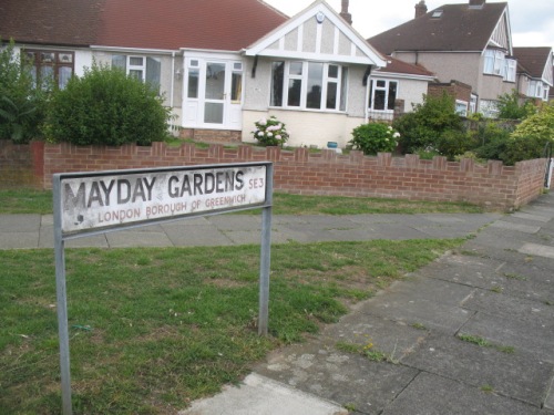
Alan Lee Williams was 10 when his home in Mayday Gardens, near Blackheath, was hit by a parachute mine. “It was meant for the Thames, but damaged 27 houses and took our roof off,” he recalls, now 84 and reflecting on a life that included a period as Labour MP for Hornchurch. Williams’ house was repaired but several houses – marked black for “total destruction” on the bomb maps – remained derelict throughout the war. “They became places for children to play,” says Williams. “They built a big water tank on them for the fire engines, and sometimes we’d swim in it.”
Visit Mayday Gardens now and you’d have no idea anything had happened here. Unlike other streets, where former bomb sites can be identified by the post-war housing blocks that interrupt Victorian terraces, the destroyed houses in Mayday Gardens were rebuilt exactly as before. “They look as if they have been there all the time and I’m sure most people living there have no idea what happened,” says Williams. Indeed, when a local resident – who declined to be named – was asked if they knew of the street’s history, they admitted it came as news to them. “There was no consistency with the reconstruction,” says Ward. “These have pretty good plots and they probably decided it would be easier to rebuild a couple of houses then build a low-rise block.” One issue would have been the material available, with bricks remaining in short supply until the 1950s despite the LCC’s ability to salvage 140 million from damaged houses. The reconstruction of these middle-class homes, though, comes as stark contrast to the way many working-class districts were treated.
Co-Op, Brook House, Shooters Hill, SE18
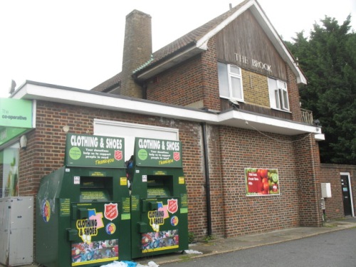
A short walk from Mayday Gardens on the corner of Shooters Hill and Corelli Road is an ugly squat building housing a supermarket. This was the site of the Brook Hotel pub, which was hit by a V2 rocket in November 1944.
Alan Williams, then 14, was one of the first on the scene. “I was on a tram on Shooters Hill, when I heard an explosion and ran down the road just in time to see a No 89 bus explode,” he says. “The pub had been hit by the missile and the bus was passing and caught fire.”
Williams was pressed into service. “The fire officer called for silence so we could listen for people calling for help and we heard somebody,” he says. “The firemen were too big to go down, so they lowered me. I found a body still breathing and helped them pull it back up. We got to the top and the gas blew up beneath us – I never got out of a bombsite so quickly.”
He’d rescued a girl who had been playing with the publican’s daughter. “She lived in the same road as me, and her father was a high-ranking policeman,” says Williams. “He came to see us – my mother thought I’d been in trouble again!” In the carnage, 29 died but the pub was rebuilt immediately. “The pub was a lovely old building,” says Williams. “It was close to where soldiers were billeted so they rebuilt it before the end of the war.” Williams passes such bombsites frequently. “I still live in the area and I bow my head as I go past,” he says. “I can still see that 89 bus exploding. I always thought it was strange that there was never an explanation of what happened to these places. I thought they should have put up plaques. It’s always a puzzle why it didn’t happen, maybe they just wanted to forget.”
There are some memorials, if you know what to look for. Churches played an important role before and after the Blitz. Bombed churches were used as propaganda – a famous wartime photograph shows St Paul’s sheathed in smoke – and London’s churches took a pounding: 624 of 701 churches were damaged, of which 91 were destroyed. Many City churches were damaged by the fire bombs of 29 December 1940, which levelled entire streets.
Almost immediately, a debate began about what to be done with the most badly damaged churches. Architect Sir Edwin Lutyen argued in 1941 that “where there is no congregation I would leave the spaces occupied by destroyed churches as open”, partly as a memorial. In 1944, a letter in The Times presciently articulated this principle: “The time will come – much sooner than most of us to-day can visualize – when no trace of death from the air will be left in the streets of rebuilt London. At such a time the story of the Blitz may begin to seem unreal not only to visiting tourists but to a new generation of Londoners. It is the purpose of war memorials to remind posterity of the reality of the sacrifices upon which its apparent security has been built. These church ruins, we suggest, would do this with realism and gravity”.
The creation of these memorial-ruins was rooted in realism – with attendances in decline, churches simply weren’t always needed. The medieval church of Christ Church, Newgate had been rebuilt by Sir Christopher Wren in 1687 after the Great Fire and then razed again in the inferno of December 1940. It has been left in its ruined state in memory of the Blitz, but in bastardised form.
In 1981, neo-Georgian offices were added in imitation of the 1760 vestry – these currently house a dentist. Two walls to the east were removed in 1974 in a road-widening scheme, while the tower – with a steeple that Ian Nairn considered one of Wren’s finest – was transformed into a 12-storey private home in 2006. Merrill Lynch’s office squeezes against the wall of the church and the fact these gardens act as a memorial to the Blitz probably goes unnoticed by local workers – it’s all far too tidy for one thing. A short-lived campaign was launched in 2013 to turn this into a more thoughtful memorial to the sacrifice of Londoners, of which there are few. Christ Church at least fared better than another memorial-ruin: St Mary Aldermanbury was sold to Westminster College in Fulton, Missouri to act as a memorial to Winston Churchill. London still awaits a fitting tribute.

Old Market Square, Columbia Road, E2
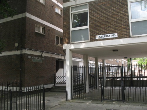
A complex network of priorities faced London’s post-war rebuilders, many of whom had been agitating to reconstruct London since before the war. This bore curious fruit in Columbia Road in Bethnal Green, now the location of a flower market and genteel Victorian terraces but then considered a slum. On the first day of the Blitz, a bomb hit a shelter beneath Columbia Market, killing 38. “Columbia Market was a 19th century development founded by Angela Burdett-Coutts to regenerate the area and improve quality of life,” explains Ward.” The buildings were damaged during the war and subsequently demolished – but, it seems, they could have been repaired – the map notes that the main blocks suffered only general blast damage.”

Burdett-Coutts was a philanthropist and friend of Charles Dickens, and Columbia Market was a combination of market and social housing constructed in a dramatic neo-Gothic style that marked one of the first flowerings of Victorian social housing. The ambitious scheme was deemed a “splendid failure” by The Times in 1936 and after the war was being used for storage. Although salvageable and unquestionably important, it was demolished in 1960 and replaced by Ravenscourt Park and a modern tower block, named Old Market Square in a half-hearted nod to what was lost. This new estate is typical of the buildings that were thrown up after the war to solve the problem of slum housing. A campaign is ongoing to get a plaque erected in memory of those that died.

In the haste to rebuild London, many important buildings were demolished, inadvertently spawning the modern heritage industry. “The idea of heritage and listing buildings only really started after the war, when things were demolished so rapidly we don’t know exactly what was demolished and what was valuable,” says Peter Larkham, professor of planning at Birmingham School of the Built Environment, who has written on post-war reconstruction. “It was launched as a problematic and ad hoc system that allowed councils to designate conservation areas. After development stopped with the 1970s oil crisis, conservation almost took over and we now have 10,000 conservation areas and half a million listed buildings. Some think we conserve too much.” The only remaining trace of Columbia Market is a section of railing outside a nursery. “It’s a fascinating building that most have cost a fortune and completely dominated the road,” says Ward. “Now you’d never know it existed.”
Palestra, Blackfriars Bridge Road, SE1

This 1990s office block sits atop a site with a fascinating jumbled history. In 1783, the Surrey Chapel was built amid fields by Georgian preacher Rowland Hill, who chose a circular – or octagonal – form as this meant there were no corners where the devil could hide. By 1910, it was being used as a warehouse when boxer Dick Burge decided to turn it into a boxing venue. The Ring was a success but was hit by a bomb on 25th October 1940 and then again in March 1941. According to the Bomb Damage Maps the spot was also later hit by a V1 flying bomb. Damage from one of these strikes can still be seen a few yards away under a railway bridge.

Like many bombsites, The Ring wasn’t replaced until the 1960s. “Some materials required for building were rationed until 1954,” says Larkham. “Every bomb-damaged city was arguing with the government for their allocation of steel and you might have a site and a plan but you might not be able to do anything with it. Britain was selling steel to Australia because the economy was more important than rebuilding.” Eventually Richard Seifert’s gaunt Orbit House was raised on the site. Seifert, one of the UK’s most prolific post-war architects, loved to give his buildings space-age names, and this one also had a circular nod to The Ring. It housed records for the India Office.
But Orbit House’s time was fleeting. In the 1990s it was replaced by Will Alsop’s gargantuan glass Palestra, which is used by TfL. Peter Rees, the City’s former head of planning, once told me that modern office buildings have a life of around 30 years – something that has more to do with the changing requirements of office life than architectural trends – and that’s how long Orbit House lasted. But with his new building, Alsop paid reference to both of Palestra’s forefathers: like Orbit House, it is raised above the road on a pedestal, while its name comes from the Greek word for a wrestling ring. What’s interesting, though, is that as with much of London’s post-war offices – include huge swathes of the City – this site is already on its second generation of development. Larkham questions if that is sustainable. “One of the worst products in terms of sustainability is concrete,” he says. “The fact we can put these building up and then pull them back – is that really the best solution? We need to design for more flexible longer-term planning.”
You won’t find Sayer Street on a map but you can hunt it down in photographs. One on the IWM website shows a family sitting at a dinner table outside the Blitzed shell of Sayer Street School eating egg and bacon supplied by American aid.

Another shows Sayer Street before the Blitz, when it consisted of five-storey tenements in one of London’s poorest areas around Elephant & Castle. Elephant was badly hit by bombs, and Sayer Street is riddled with damage on the Bomb Damage Maps. Before the war, the street contained a fishmongers, cat meat dealer, grocer, saddler, bookbinder; after the war, it was the location of a car park, one of the most popular post-war uses for bombsites. The NPC car park empire began with the purchase of a £200 bomb site on Red Lion Square.
In his memoir The Likes Of Us, Michael Collins writes how in the 1960s he explored Elephant’s remaining bombsites, “on which relics of former homes hovered, exposed broken fireplaces and floral or barley corn wallpaper that had witness births, deaths, Christmases, parties, tears, arguments, laughter and sex.” Sayer Street survived this half-life into the 1960s, when it was chewed up by the Heygate Estate. The Heygate was originally conceived as one of three gigantic housing estates that would stretch from Elephant to Peckham, linked by walkways and ramps for two miles. “It was said the planners decided which streets would be erased in the back of a taxi as they were driven around the neighbourhood,” writes Collins, who was forced from his childhood home. One of those to disappear was Sayer Street.
As Larkham explains, “some of the plans were incredibly radical, sweeping away neighbourhoods irrespective of damage and replacing them with high-rise towers nobody wanted to live in.” These were fuelled by idealism, but as early as 1945, the planner CB Purdom had warned of the dangers in How Shall We Rebuild London?, explicitly rejecting Le Corbusier and “the megalomaniac proposals of those who regard the metropolis as a hive of near termites speeding their existence upon escalators or in tubes.” Such pleas were ignored and towers went up on bomb sites all over London. Some were successful like the Barbican, but most were bleak, poorly built and badly maintained.

The Heygate was rarely popular but it housed many of London’s poorest and now it too is gone, having lasted 37 meagre years. Southwark sold it to Land Lease, a private developer and demolition began in 2011. Former residents have been shipped miles from London, displaced even more brutally than those who once lived on Sayer Street. In its place will come Elephant Park, a residential village of towers and plazas, where a three-bed apartment costs £2.5m. “It says a lot about where London is heading, how it is become more like Paris with those areas of social housing being pushed further out,” says Ward. The ripples from London’s post-war redevelopment continue to be felt, and from Blitzed streets and lost bombsites, another London arises. How long will this one last?


Pingback: Gobbets of the week #23 | HistoryLondon
Reblogged this on First Night History and commented:
Death and destruction from the Blitz during WWII is one thing but my heart weeps again at the horrors built in the post-war period, and torn down, only to be replaced with further monstrous edifices. No affordable housing, of course.
Ravenscourt Park is actually located 10 miles west. I think you meant Ravenscroft Park.
I was surprised and happy to see Sayer Street reappear on the map! I just noticed it today. (Google Maps March 22, 2019) My grandfather was born there in the mid 1890’s. It was quite a journey for me to even find where Sayer Street had been, after it was torn down and replaced by the Heygate Estates years after the Blitz. I finally found it on Charles Booth’s Poverty Maps. Nice to see that someone is paying attention to history.